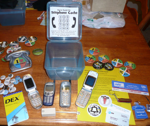
I know I’m being annoying about Geocaching lately, but ever since I got this new program for my Blackberry I’m suddenly really into Geocaching again. Today I spent about 3 hours biking around Albany, finding caches by myself. I think this is the first time I’ve ever geocached by myself. I found 4 caches and failed at 4 others because there were too many people nearby. I just wrote this review of the new program on some geocaching forums and now I’m going to annoy everyone else with it too. So here you go…
I’ve gone through quite a few methods of Geocaching since I started in 2004. For my first year, I lugged a full sized laptop around with me with a big USB GPS thing attached to it. Surprisingly I never dropped my laptop while climbing up rocks, through forests and around lakes. Then for awhile, I used an HP organizer, connected to a wireless GPS via Bluetooth. That was nice for a couple years, but it sure was a lot of extra gadgetry to own.
For the past year, I’ve been using my Blackberry phone to find Geocaches. It’s got built-in GPS and free Google Maps, so I just print out the geocache on paper, manually type the coordinates into Google Maps and follow the dot until I get there. I’ve tried a few Blackberry applications for Geocaching, but I never really found one that I liked. Until now.
About a month ago, I decided to look around for Geocaching software for my Blackberry phone once again. This time I came across a program called Geocache Navigator. It seemed like a nice program, so I decided to give it a try. The catch was that it would cost $5.99 per month for a subscription or $39.99 per year. I’d have to like a program an awful lot to pay a subscription for it. I gave them $5.99 to try it out for a month.
I can’t express how much I love this program. It does everything I could possibly need. When I turn on the program, it immediately finds my coordinates via GPS. Then I can click one button to find all the Geocaches that are near me. I’ll get a list that looks like this:
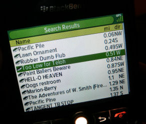
Check out how it lists the distance from each cache. Those numbers automatically update as I walk around. And when I click on the cache that I want to retrieve, I get to choose from these screens:
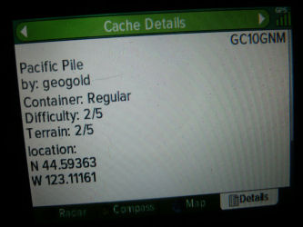
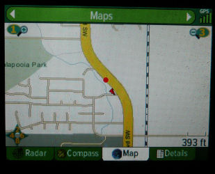
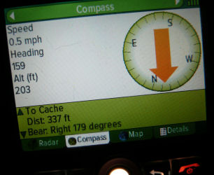
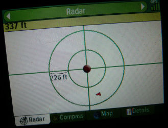
My favorite for zeroing in on a cache is the “radar” screen. From the Cache Details screen, I can read the full description of the cache, look at all the log entries and even view the unscrambled clue. The GPS claims to work to within 3 feet of the coordinates, though I’m unsure if GPS is really that precise. The map section allows me to view street maps, topographical or aerial photos.
This program makes geocaching completely spontaneous. Like a couple weekends ago I was in downtown Portland and had some time to kill, so I viewed the caches around me, picked the closest one and went to find it. It’s so great not having to put any effort into looking on the website and printing out cache info anymore. I can just whip out my phone anytime I want, wherever I am, and go Geocaching. Preparation is a thing of the past.
Another advantage this program has over using Google Maps, is that this program will keep working even when your internet goes out. I ran into a problem earlier this year when I was in the woods, using GPS and the map would no longer load because I wasn’t getting good reception anymore. The GPS still worked, but it was just a red dot on a completely white screen so it was useless. This program will continue to track the coordinates even when the internet connection dies.
Here are my few gripes about this program…
1. I can’t log my find on geocaching.com from within the program. For that, I still have to visit the website when I get home and log it like usual. I suppose I could log it from my phone’s web browser, but I’ve never bothered to try. If I could log my find, I’d never have a reason to even visit geocaching.com again.
2. The aerial and map view doesn’t zoom in far enough. When I’m using my Google Maps application to geocache, I can zoom in pretty close which makes tough caches a lot easier to find. If I’m really stuck, I suppose I could copy/paste the cache coordinates into Google Maps (since the Blackberry allows you to cut and paste, unlike some other nameless overhyped phone), but that’s extra effort. I wish the program could just zoom as much as Google.
3. The price. I really shouldn’t complain about that since $39.99 comes out to just $3.30 per month if I pay for a year up front. It’s worth every penny of that. Disregard this complaint. I just hope they don’t suddenly realize how awesome they are and start charging $10/month for this.
If you have a Blackberry that lets you use your GPS (sorry Verizon Wireless users) then you should definitely give this program a try. I’m loving it and plan to pay for a year of usage very soon. This program is spoiling me and making me wonder how I ever got along without it. You can find it at www.geocachenavigator.com for Blackberry and a few other smartphones.
The Geocaching was fun today. I discovered a few new places in Albany and found 4 microcaches. I want to find every cache in Albany, so I’m going to work on finding the micros by myself and the bigger caches for when I’m with the kids. Micros are usually in 35mm film canisters and only contain a log sheet. The bigger ones have toys and other random junk in them, which is what the kids enjoy trading for.
One of my finds today was underneath a pay phone in front of a convenience store curiously named the GPS Market. Another was hidden inside a guardrail. And the one that took me the longest to find was hanging in plain site from the remains of a hundred year old bridge. I spent over 30 minutes searching for that one. One of my failures required me to climb up a pine tree. I only didn’t because I was alone and people were around. I’m betting it’ll be much quieter there tomorrow morning though. I think I’m going to spend half the day doing this again tomorrow.

